Map of San Miguel de Allende – Centro
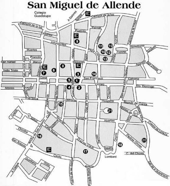
Click to enlarge
San Miguel de Allende City Map key (‘E’ are parking lots)
1. San Miguel de Allende’s Jardin (Town Square)
2. Church – San Miguel de Allende’s Parroquia (Parish Church)
3. The Presidencia Municipal (San Miguel’s City Government Offices)
4. Casa de Allende, family home of Ignacio Allende, now a museum.
5. Casa de Canal (Another large, colonial-era home home, also houses an appointment only museum.)
6. rt School – Bellas Artes – Converted nunnery, now houses one of Mexico’s most prestigious art schools.
7. Church – Templo Las Monjas – one of San Miguel’s most beautiful churches
8. Teatro Angela Peralta
9. Biblioteca Publica de San Miguel
10. Church – El Oratorio de San Felipe Neri
11. Church – Nuestra Señora de la Salud
12. Colegio de Sales
13. Plaza de Allende – San Miguel’s Civic Plaza
14. Church – Templo de San Francisco
15. Casa del Inquisidor – Home of San Miguel’s (Spanish) Inquisition Representative
16. Art School – Instituto Allende
17. Parque Juarez – a beautiful park with large 100-year-old + trees
18. El Chorro – Springs where San Miguel was founded, also Lavados – where many in the community still do their washing.
19. Mercado de Artesanias – Artisans Market
20. El Mirador – San Miguel de Allende’s “Lookout Point” – panoramic vista of historic district
21. Plaza del Toros – Bull Ring